Geospatial Analysis of Heavy Metal Intrusion in Groundwater Resources of Isoko North Local Government Area, Delta State, Nigeria
A GIS and AHP Approach
DOI:
https://doi.org/10.54117/jpmesc.v4i1.13Keywords:
Boreholes, geospatial, groundwater, heavy metals, intrusion, rocksAbstract
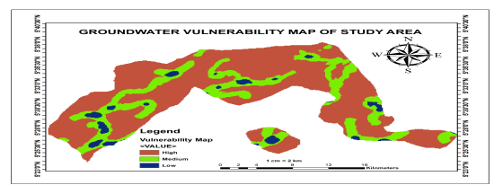
This study compared the regional variations of heavy metal intrusion in subterranean water resources of Isoko North Local Government Area, Delta State, using ten (10) spatially distributed boreholes. The data were subjected to the Heavy Metal Index (HMI) technique to determine the significant contamination rate (with the World Health Organization Standard and the Nigerian Standard for Drinking Water Quality as the control variables). The investigation revealed that lead (Ppm) values ranged from 0.11 to 0.18, with higher concentrations in Owhelogho (0.18), Iyede (0.18), and Ellu (0.17). The Iron (Ppm) value ranges from 0.31 to 0.43, with all locations having significant values slightly higher than the WHO and NSDWQ norm of 0.3. The heavy metal index test yielded a class "II" grade, suggesting the presence of lead and iron oxide in trace amounts. The groundwater potentials and vulnerability assessment level results were validated using the AHP Pairwise analysis program. Rainfall, height, slope, drainage density, lineament density, land use land cover (LULC), and geology are among the components evaluated. It is significant to highlight that rainfall, accounting for 25.88%, and geology, accounting for 23.79%, are the two primary influencing elements in heavy metal contamination of groundwater in the area. The area's vulnerability model, created using a GIS-based weighted overlay, shows 75.5% of the area to be highly vulnerable, 17.22% moderately vulnerable, and 7.29% lowly vulnerable.
Downloads
Published
Issue
Section
License
Copyright (c) 2025 Michael N. Oyem, Jacob Meye, Hector Henry Oyem, Ufuoma E. Ogbijara, Samson O. Okpo, Akpomrere Rufus

This work is licensed under a Creative Commons Attribution 4.0 International License.
